Welcome to DU!
The truly grassroots left-of-center political community where regular people, not algorithms, drive the discussions and set the standards.
Join the community:
Create a free account
Support DU (and get rid of ads!):
Become a Star Member
Latest Breaking News
Editorials & Other Articles
General Discussion
The DU Lounge
All Forums
Issue Forums
Culture Forums
Alliance Forums
Region Forums
Support Forums
Help & Search
Tropical Storm Danas

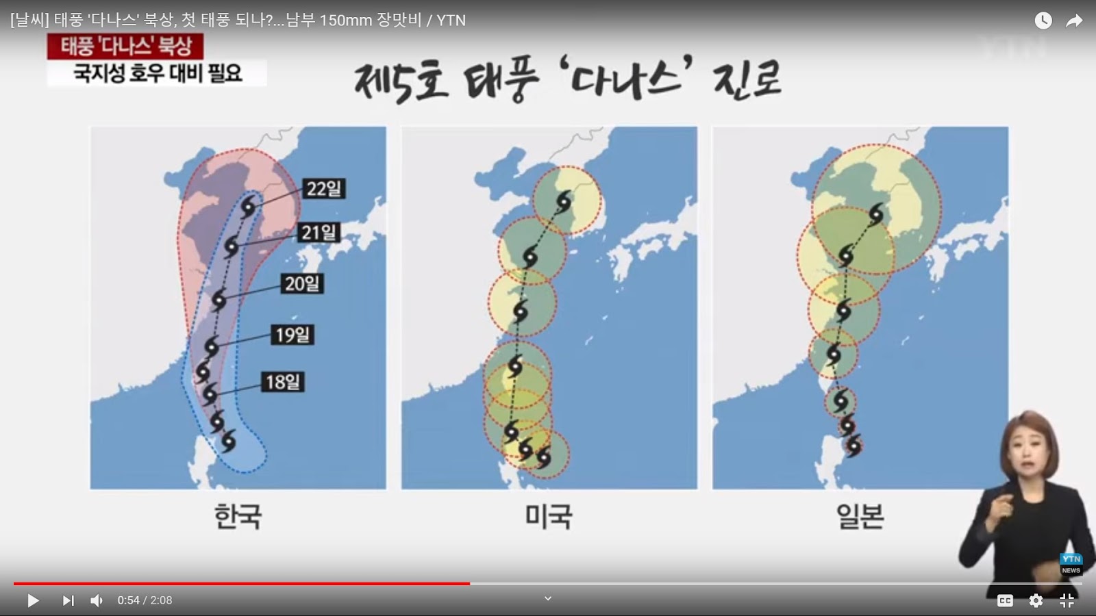
(Source- YTN news July 16) Will Danas become the first Typhoon? Projected route of Danas according to South Korea, US, and Japan weather services. The US projected route anticipates that Danas will make landfall on China near Shanghai, continue northward and later pass Cheju Island and enter the West Sea/Yellow Sea approaching the buffer zone around the Northern Limit Line between North and South Korea about July 21. The Korean report referred to the storm as a "typhoon" 태풍 颱風 but expected wind speeds were not reported. South Korean forecasters are anticipating heavy rains now during the traditional rainy season. Today 150mm of rain in the Southern peninsula region is expected. There is some concern about about the increased potential for damaging rains and flooding in Korea given the expected route of Danas.
CWB issues sea warning as Tropical Storm Danas makes beeline for Taiwan
CWB issues sea warning for Tropical Storm Danas, land warning expected soon
By Keoni Everington, Taiwan News, Staff Writer
2019/07/17 09:59
TAIPEI (Taiwan News) -- The Central Weather Bureau (CWB) has issued a sea warning for Tropical Storm Danas and a land warning is expected before noon today.
Tropical Storm Danas, which in Tagalog means "experience," became the fifth official tropical storm of the year on Tuesday (July 16). At 11:30 p.m. on Tuesday evening, the CWB issued a sea warning for Danas as the center of the storm closes in on the Bashi Channel.
As of 2 a.m., the CWB said that the tropical storm had a radius of 150 kilometers and was located 500 kilometers south-southeast of Taiwan's southernmost tip of Eluanbi, and moving north-northwest at a speed of 16 kilometers per hour (kph). It was packing maximum sustained winds of 64 kph with gusts of up to 90 kph.
More: https://www.taiwannews.com.tw/en/news/3746105
2 replies
 = new reply since forum marked as read
Highlight:
NoneDon't highlight anything
5 newestHighlight 5 most recent replies
Tropical Storm Danas (Original Post)
soryang
Jul 2019
OP
soryang
(3,308 posts)1. Danas route moves further east
Tropical Storm Danas to move further east off Taiwan
By Matthew Strong, Taiwan News, Staff Writer
2019/07/17 19:36
https://www.taiwannews.com.tw/en/news/3746539
The weather bureau said that later revisions of the storm’s route were likely, and Danas could actually take a path still further away from Taiwan’s main island and barrel toward the Korean peninsula, the Central News Agency reported.
On Tuesday (July 16), initial reports had predicted Danas would make landfall in Taitung County and cross the island to emerge in the Taiwan Strait near Hsinchu before heading toward Shanghai.
Even with the latest changes, Taiwan still needed to prepare for large amounts of rain and strong winds, with landslides, falling rocks and flooding in lower areas still posing risks to residents, reports said. Members of the public were advised against staying close to the coastline to watch the waves, and against traveling in the mountains during the storm.
The worst weather was expected to hit Taiwan Thursday (July 18) and early Friday (July 19).
nitpicker
(7,153 posts)2. Now a tropical depression