Welcome to DU!
The truly grassroots left-of-center political community where regular people, not algorithms, drive the discussions and set the standards.
Join the community:
Create a free account
Support DU (and get rid of ads!):
Become a Star Member
Latest Breaking News
Editorials & Other Articles
General Discussion
The DU Lounge
All Forums
Issue Forums
Culture Forums
Alliance Forums
Region Forums
Support Forums
Help & Search
Science
Related: About this forumThis Map Lets You Plug in Your Address to See How It's Changed Over the Past 750 Million Years
This article was published in 2019. Didn't see it until a few minutes ago.The interactive tool enables users to home in on a specific location and visualize how it has evolved between the Cryogenian period and the present
Meilan Solly
Senior Associate Digital Editor, History
February 15, 2019
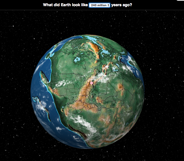
During the early TrSome 240 million years ago, the patch of land that would one day become the National Mall was part of an enormous supercontinent known as Pangea. Encompassing nearly all of Earth’s extant landmass, Pangea bore little resemblance to our contemporary planet. Thanks to a recently released interactive map, however, interested parties can now superimpose the political boundaries of today onto the geographic formations of yesteryear—at least dating back to 750 million years ago.
The results are intriguing: During the early Triassic epoch, the National Mall in Washington, D.C., for example, was wedged almost directly adjacent to Mauritania, yet to be separated from the Northwest African country by the vast waters of the Atlantic Ocean.
Ancient Earth, the tool behind this millennia-spanning visualization, is the brainchild of Ian Webster, curator of the world’s largest digital dinosaur database. As Michael D’estries reports for Mother Nature Network, Webster drew on data from the PALEOMAP Project—spearheaded by paleogeographer Christopher Scotese, the initiative tracks the evolving “distribution of land and sea” over the past 1.1 billion years—to build the map.
Users can input a specific address or more generalized region, such as a state or country, and then choose a date ranging from zero to 750 million years ago. Currently, the map offers 26 timeline options, traveling back from the present to the Cryogenian period at intervals of 15 million to 150 million years.
More:
https://www.smithsonianmag.com/smart-news/map-lets-you-plug-your-address-see-how-neighborhood-has-changed-over-past-750-million-years-180971507/
2 replies
 = new reply since forum marked as read
Highlight:
NoneDon't highlight anything
5 newestHighlight 5 most recent replies
= new reply since forum marked as read
Highlight:
NoneDon't highlight anything
5 newestHighlight 5 most recent replies
= new reply since forum marked as read
Highlight:
NoneDon't highlight anything
5 newestHighlight 5 most recent replies
This Map Lets You Plug in Your Address to See How It's Changed Over the Past 750 Million Years (Original Post)
Judi Lynn
Mar 6
OP

Bok_Tukalo
(4,445 posts)1. Arthur Dent didn't need it!
Cool.

Big Blue Marble
(5,590 posts)2. Thanks
Fascinating App! I have tiny fossil shells in my yard and knew that at one time we were
"under water." Now I know when and for how long. Much farther back in time than I would have guessed.